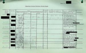
Proposed Land Tribunal
In late 1960s, there was a proposal to set up a New Territories Land Tribunal with statutory power to adjudicate boundaries and to replace the DD Sheets with 1:1200 Land Record Plans, known as Cadastral Survey Sheets.
In order to have the Cadastral Survey Sheets suitable for adjudicated by the proposed Land Tribunal and for direct adoption as new Land Record Plans, the method of correlation was changed to “Agreed occupations” instead of adopting the title boundaries faithfully.
Lots Record Sheets
A new Cadastral Survey Revision procedure for the production of Cadastral Survey Sheets was formulated. A DD Lots Record File was opened for keeping the Lots Record Sheets (NTA Form 48B) for all Lots in that Demarcation District up to and including the last Lot Number used at the time of compilation of the Cadastral Survey Sheets.
Lot Numbers were printed by using Automatic Numbering Machine and a Serial Number was given to each Lots Record Sheet. Where there were a number of sub-divisions of a Lot, these were shown in running order. The Registered Area, DD Plan Area, Occupied Area and Cadastral Sheet Plan Area of each Lot were entered. Discrepancies in areas were entered in a separate column of the Lots Record Sheet.
Then, the Land Bailiffs conducted field investigation. the Land Bailiffs might consult the registered owners, village representatives and other interested parties. They would give sufficient notice regarding the date and time of visit. They would also requested registered owners to bring any pertinent documents which would help to resolve boundary issues.
During the field investigation, the Land Bailiffs recorded in the Lots Record Sheet giving details of how the boundaries were defined. The specimen entries were:
- Occupation boundaries defined on ground by a fence/wall/bund/etc.
- Individual lot boundaries undefined, but an external boundary enclosing Lots No. defined by a fence/wall/etc.
- Occupation boundaries encroach on Lots No./Crown Land.
The boundaries that were agreed/acceptable were marked in red on the Quarter Sheets. Where there was doubt about the acceptability of occupied boundaries, they were marked in green on the Quarter Sheets. Where there were no defined boundaries, “Boundaries undefined on ground, title boundaries to be accepted” was recorded in the Lots Record Sheet.
When the field investigation had been completed and all relevant information recorded, the Lots Record Sheets and the Quarter Sheets were returned to the Cartographic Staff for the next stage action.
Today, the Lots Record Sheets and Cadastral Survey Sheets, if available, are essential office records for the re-establishment of boundaries of old Government Leases. This is because the agreements on boundaries made between Government and Lot owners were recorded on the Lots Record Sheets during the Cadastral Survey in 1960s (See Law of Boundary Agreements).
