Demarcation District Field Sheets (丈量約份實地測量圖)
The Demarcation District Field Sheets (DD Field Sheets) means the actual survey plans drawn by plane table method during the Demarcation District survey (DD survey) carried out between 1899 and 1903.
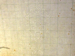
The Field Sheets were made of “Whatmans Paper” with plan size of 28” by 20”. Grids of one-inch separation were pre-printed in blue and there were watermarks of the manufacturer on the Field Sheets.
The whole New Territories (including those districts re-named as New Kowloon) were divided into 477 Demarcation Districts (known as “Survey District” in New Kowloon) with an area of about 200 acres for each district.
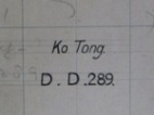 The DD Number (some with village names) was annotated on each Field Sheet.
In the beginning of the DD survey, the topographic survey and the demarcation were conducted separately. The scale of the survey plan was 1:3960.
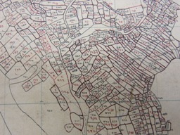 The surveyor surveyed details by radiations from traverse stations and plotted them in pencil on the Field Sheets. The surveyor also annotated a number (the field number) for each cultivation field or enclosed area.
Subsequent to the topographic survey, the surveyor accompanied the demarcator to the field and conducted the demarcation. On the Field Sheet, the surveyor annotated another number (the lot number) for each land parcel, which might consist of more than one cultivation field. Since there are two numbers for each land parcel, namely the field number(s) and the lot number, these DD Field Sheets are commonly known as the “Double Lot Sheets” (雙編號地段測量圖).
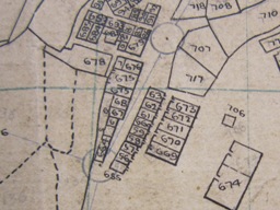 Soon afterwards, the 1:3960 scale was found inadequate for showing the details and the 1:1980 scale was adopted. To speed up the DD Survey, the survey and demarcation were conducted simultaneously. Therefore on the 1:1980 Field Sheets, the surveyor and the demarcator used the same number (the lot number) for each land parcel.
In the field, the details were plotted and the lot numbers were annotated also in pencil on the 1:1980 Field Sheet. After the Field Sheet was checked by the inspectors, the details and field/lot numbers were faired with black (lot numbers in red on the Double Lot Sheets) in office. Most survey controls were left un-inked on the DD Field Sheet.
All Field Sheets were signed by Mr J. W. Newland.
 Some Field Sheets were stamped with the signatory of the in-charge Mr Geo. P. Tate.
Nowadays, many Original DD Sheets (mentioned below) attached to the Block Government Leases have become dilapidated or illegible. The DD Field Sheets, if available, are essential survey records of the DD survey to assist in identifying the land parcels.
 DD Sheets (Sun Prints) (晒本丈量約份地圖)
Subsequent to the DD survey, the New Territories Land Court carried out the registration and the adjudication hearing of claims of title.
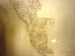
The details of the DD Field Sheets were traced onto translucent papers in order to supply the “Sun Prints” (so called because of its production method) for use by the Land Court. The material of the Sun Prints was linen-backed paper with brownish appearance. The details on these Sun Prints are now dark brown due to aging.
On most Sun Prints, the Demarcation District was annotated as “DEM. DT.”. Different from the DD Field Sheets, grids and field numbers were not shown, and field bunds within the same land parcel were replaced by peck-lines. The signature of Mr Newland was retained on most Sun Prints.
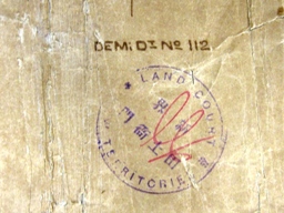 A number of Sun Prints were produced for each Demarcation District. A Sun Print was attached to the respective Block Government Lease, now often referred as to the “Original DD Sheet” (正本丈量約份地圖). The chop of the New Territories Land Court with signature was put on most Original DD Sheets.
Today, the Original DD Sheets are kept by the Land Registry. The Original DD Sheets attached to the Block Government Leases are the “legal” plans.
 Another Sun Print of each Demarcation District was kept by the Surveyor’s Office of the then Public Works Department. The chop of the Surveyor’s Office with signature was put on these Sun Prints.
Some of these Sun Prints are now kept by the District Survey Offices of the Lands Department and they are now known as the “DD Sheets (Sun Prints)” (晒本丈量約份地圖).
Notwithstanding originated from the same master Field Sheet, the Original DD Sheet kept by the Land Registry and the Sun Print of the same Demarcation District kept by the District Survey Offices might be different in contents probably because the subsequent marking up or addition of information on them after the issue of the Block Government Leases in 1905 were carried out by the District Offices of the then New Territories Administration and the then Public Works Department separately.
As mentioned in previous paragraph, many Original DD Sheets attached to the Block Government Leases have become dilapidated or illegible. The Sun Prints kept in the District Survey Offices, if available, are essential office records to assist in identifying the land parcels.
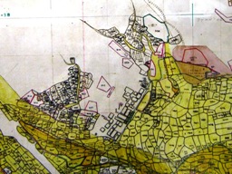 DD Control Sheet(丈量約份控制圖)
After the issue of the Block Government Leases in 1905, a separate set of Sun Prints were used for recording the New Grant Lots and mutations in land status. These Sun Prints were referred as to the “DD Control Sheets”. On these DD Control Sheet, additional lots were indicated in red, and lots resumed or surrendered were crossed or tinted in yellow.
From time to time, new editions of DD Control Sheets were re-produced due to dilapidation of the existing DD Control Sheets. In each new edition, new granted lots and subdivisions were inked black and lots resumed and re-entered were dropped.
The early editions of the DD Control Sheets were Sun Prints of linen-backed paper with edition dates mostly untraceable. There was probably no retrace work before 1946, since different editions of the same DD Control Sheet seemed originating from the same Sun Print.
After the war, new editions of the DD Control Sheets were mostly produced from their previous editions by photographic method on silver bromide paper and backed with cardboard. As could be seen from the existing DD Control Sheets, there were two major updating exercises conducted in 1950’s and 1970’s.
When the new editions of the DD Control Sheets were issued, the previous editions were shelved or destroyed in some District Offices of the then New Territories Administration. As such, only the latest editions of the DD Control Sheets are kept in some District Survey Offices of the Lands Department today.
Since the documents of title to many New Grant Lots were lost during the war, the DD Control Sheets kept in the District Survey Offices today are essential office records to assist in identifying such land parcels.

Oct 10, 2013 @ 16:31:08
Dear Mr. Cheung,
From your post, I know that the demarcation district would be called as “survey district” in the “New Kowloon” area. But why certain area in New Territories, such as Tai Po, etc. would also called “survey district” in the relevant Block Government lease. I understand that there may be no actual difference between the two terms but whether you have any information from the Government to recognize these two terms. Thanks in advance for your assistance and reply.
Oct 10, 2013 @ 19:53:32
“Demarcation District” and “Survey District” are synonymous in early 1900s. To avoid confusion, only “Demarcation District” has been used in the New Territories since 1910s or 1920s.
Apr 15, 2013 @ 14:49:37
Dear Mr. Cheung
For terraced field, the separation between the upper and lower bund is quite large. I think the middle line between them is not reasonable to be considered as the lot boundaries. In such case, is there any record telling that whether the boundary line as depicted on the DD Sheet followed the upper or the lower bund of the terraced field.
Thank you very much.
Apr 16, 2013 @ 17:46:00
There was an ancient Chinese tradition「上田管下埂」. However, it is not known whether or not this tradition was applied during the DD survey.
The Demarcation Rules, Appendix A of Report on the New Territories for 1901 reads:
“The object of Demarcation is to ascertain on the spot the exact position and area of each individual holding in order that it may be recorded in the Survey Map and an appropriate Lot Number given to it. …. Notices should be distributed in the adjacent villages for at least one week before beginning work of the Demarcator and his coolies should go about and inform people that they must come forward and point out their land. The evening before Demarcation begins the area it is expected to cover on the following day should be marked out with tall bamboos surmounted with a red flag, these should be left standing, while the work goes on, to show the villagers on what land the Defalcator is working. ….. Having ascertained who is the person whose name is to be shown as owner, mark out the limits of the lot carefully with bamboos, one at every angle and give it a Lot Number. ….. Fields on either side of a stream or road must be demarcated separately. ….”
Accordingly, the bamboos were placed at positions pointed out by the landowner at their discretion at terraced fields.